Category:Burmis Tree
Jump to navigation
Jump to search
| Object location | | View all coordinates using: OpenStreetMap |
|---|
|
Burmis Tree has an entry on OpenStreetMap (show). |
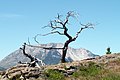
Deceased limber pine  | |||||
| Upload media | |||||
| Location | Alberta, Canada | ||||
|---|---|---|---|---|---|
 | |||||
Media in category "Burmis Tree"
The following 3 files are in this category, out of 3 total.
-
 2016-07-01 Burmis Tree (28589801823).jpg 1,600 × 1,068; 1.12 MB
-
 2016-07-01 Burmis Tree (29102421562).jpg 1,600 × 1,068; 1.62 MB
-
 BurmisTree.JPG 1,856 × 1,236; 2.76 MB
.jpg)
.jpg)